
Showing posts with label American prehistory. Show all posts
Showing posts with label American prehistory. Show all posts
Tuesday, January 26, 2016
Ghosts From Tonight 316 Years Ago
Tonight at about 9:00 p.m. Pacific Standard Time, a M9.0+ earthquake struck the Pacific Northwest, Northern California, and Southwest British Columbia. It was generated by a full rupture of the Cascadia Subduction Zone, a large subduction zone roughly equivalent of the one which caused the Great Tohoku Earthquake in Japan in 2011. This event generated a Pacific-wide tsunami which caused damage in Japan where it was recorded by monks as an "orphan tsunami" as there was no quake in Japan to which it could be attributed. Given Native American oral traditions and tsunami deposits along the coasts of Oregon and Washington, it is clear that there were casualties among local peoples at that time. This earthquake generated lasting topographical changes where parts of the coast were sunk below sea level killing these sitka spruce trees whose roots previously had been in freshwater above the heavier seawater level and in some cases the forests were dropped into the sea as the ocean extended inland. Such a case happened with the Neskowin Ghost Forest along the Oregon Coast in Tillamook County. Before tonight I had not previously seen this haunting relic of not only the 1700 earthquake, but in the case of some trees, other such events over the course of the past two millennium or so. Over that period, successive great quakes have lowered the land in this region. However, the most recent event alone dropped this area by up to 30 feet in elevation.
Friday, January 30, 2015
Drought And History At Santa Margarita Lake
Today, after an extended absence from taking day hike excursions out into the hinterlands of San Luis Obispo County, my brother by another mother, Mike and I finally got out for a trek on the east side of Santa Margarita Lake (Salinas Reservoir) off of River Road via Pozo Road. The last time we visited this location was over a month ago and around the general time-frame that California had its big December 2014. Consequently, it was a lot wetter then in contrast to today. I found it shockingly dry despite those rains last month. The only sign that rain even happened was all the germinated green grass mingled with even more brown, dry, dead grass. Most shocking was the complete absence of any glimpse of the waters of Santa Margarita Lake. Of second-most interest today was our discovery of some relics of earlier eras of human activity in what is now the area of the lake-bed.
 |
| After getting off the beaten path I spotted this concrete structure which normally should be under the waters of the lake. |
 |
| I hiked down to the concrete structure to investigate further and attempt to determine its former purpose. |
 |
| Upon viewing it from the south I determined it was a bridge for the former Pozo Road before the lake was formed. |
 |
| In a normal summer this lake is a great fire break. This year the lake-bed will invite fire across its surface. Note: this is the old Salinas River-bed heavily silted up due to the existence of the lake here since 1941. |
 |
| Mike and Oscar made a discovery on this eroded stone outcropping just above the aforementioned concrete bridge ruin. |
 |
| Chumash bedrock mortars. |
 |
| The choice of location for this bedrock mortar site is obvious given it is at the junction of the Salinas River and a tributary. |
 |
| My little monster amidst these wildflowers. I fear this may be as vivid as wildflowers get this year in the North County. |
 |
| The bed of the Salinas River is outlined as a swath down the middle of the dead reed-covered dry bed of the eastern end of Santa Margarita Lake. |
 |
| We found the remains of an old park outhouse... again off the beaten path we usually take here. All photos by Kim Patrick Noyes (all rights reserved). |
Monday, January 26, 2015
This Was Happening 315 Years Ago Now!
 |
| At this time tonight 315 years ago Pacific-wide tsunami looking very much like this graphic depicts and triggered by a M9.0+ megathrust earthquake on the Cascadia Subduction Zone was unfolding on the west coast of North America and eventually the entire Pacific Ocean Basin to varying degrees of intensity. |
Tuesday, August 26, 2014
My Mission, Indians, & Hacienda Jaunt
Today I accompanied my friend Marty on a short expedition to Fort Hunter Liggett to see Mission San Antonia de Padua and the Julia Morgan-designed Milpitas Ranchhouse a.k.a. "The Hacienda" as well as visit Indians on the Monterey District of the Los Padres National Forest all of which we accomplished. What follows is a photographic account of the high points of the endeavor which was my first visit to this area since prior to the 2008 Indians Fire which consumed 80,000 acres during which time the nearby twice-as-big 162,000-acre lightning-caused Big Basin Fire burned into it and they merged. There was evidence of this fire to be seen everywhere we were within the burn area. There was also notable evidence of recent wildfires from earlier this year which burned exclusively within the boundaries of FHL.
*Note: all day people in the area were telling me it was just called "The Hacienda" and not what I was calling it, to wit, "Milpitas Ranchhouse". A most cursory investigation online confirmed I was not losing my mind and both names are appropriate as are a couple of other variants.
*Note: all day people in the area were telling me it was just called "The Hacienda" and not what I was calling it, to wit, "Milpitas Ranchhouse". A most cursory investigation online confirmed I was not losing my mind and both names are appropriate as are a couple of other variants.
 |
| Front entrance to Mission San Antonia de Padua where a new traffic pattern was discovered and seismic retrofit construction fully underway now three weeks into a $15 million project. |
 |
| My friend Marty trying to track down a roof tile memento... which he scored shortly after this image was captured. |
 |
| View from the courtyard. |
 |
| I had forgotten this fountain was here. |
 |
| Despite the changes I found here the courtyard at least was unchanged. |
 |
| The roses here gave off a wonderful fragrance which caused me to temporarily forget I don't especially like roses. |
 |
| This fountain "makes" this courtyard. |
 |
| This is located in front of the mission. |
 |
| We visited the most excellent little museum located at the front of this mission. |
 |
| As those who know me know this sort of thing is right up my alley. |
 |
| These roof rain drain pipes are most cleverly-designed as noted by Marty. |
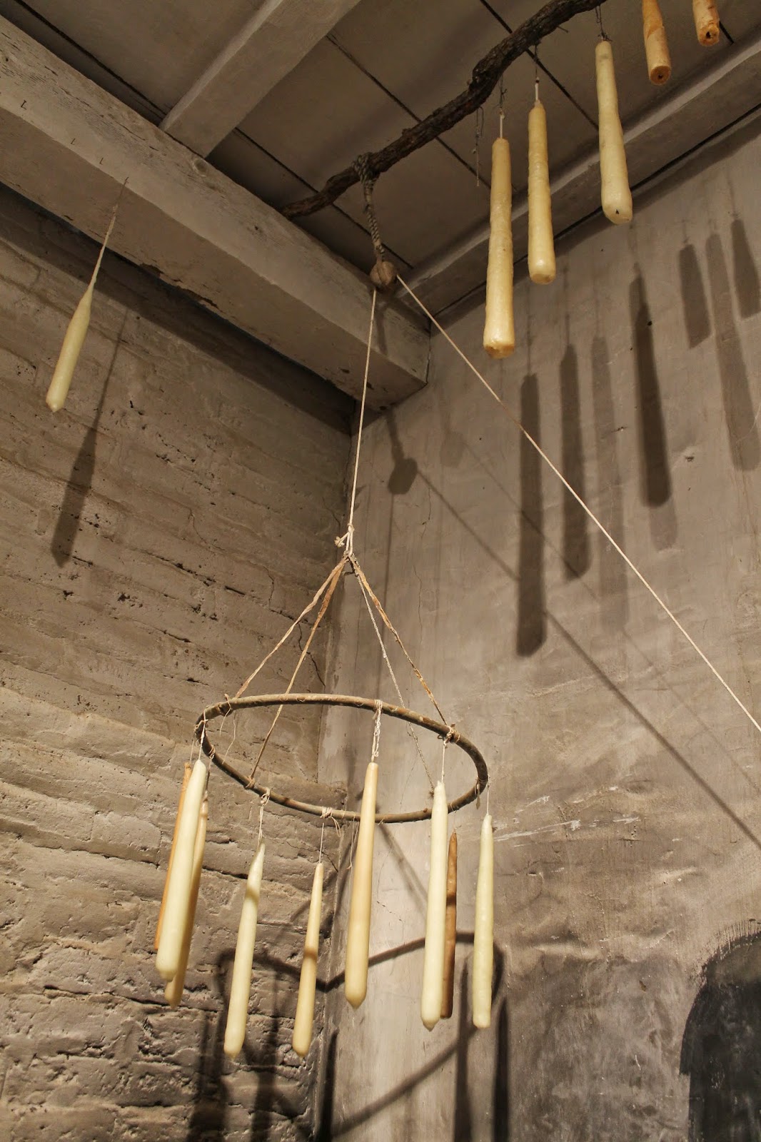 |
| Most Californians don't know the economy of the California region was once dominated by the hide and tallow trade. |
 |
| Pre-electricity the only preservatives of note were cool, dry cellars and fermentation. |
 |
| Note the notches on the wood beams. |
 |
| Manos and matates are a common sight in the mission museum. |
 |
| One of my favorite artifacts are these mano and matate combinations. |
 |
| It is slightly jarring to first notice this symbol on these old pre-Third Reich baskets. |
 |
| The second thought to come to mind seeing these swastikas with the eagle is some sort of pulp fiction serial storyline with Nazis going back in time and influencing ancient cultures. |
 |
| I can't help myself from photographing these things. |
 |
| The east wing of the main mission structure was never rebuilt and never will be, but makes an excellent archaeological site. |
 |
| Salinan bedrock mortar in bedrock in Arroyo Seco headwaters creek. |
 |
| Despite the severe drought there are vernal pools in the headwaters of the Arroyo Seco. |
 |
| This is Indians and the open area here features a most desirable vibe and view. |
 |
| View southeast from the probable camp or village site. |
 |
| View west-northwest into the Ventana Wilderness Area of the Monterey District of the Los Padres National Forest. Note the bedrock mortars in the foreground. This was undoubtedly a Salinan camp or village site at some time. |
 |
| I could easily imagine this overhang being used for shelter in conjunction with a lean-to. |
 |
| Junipero Serra Peak behind the Indians meadow. |
 |
| Me being the dork I am I always notice that white layer on the mountain in the background and wonder what formed it. |
 |
| Closer view of the curious geologic feature on the nearby mountain and of the lean-to friendly overhangs in the foreground. |
 |
| The fire lookout atop Junipero Serra Peak is no longer visible so I assume it burned in 2008. |
 |
| The up-lifted sedimentary layers at Indians always give me pause to think about the earthquakes that are still uplifting them. |
 |
| The Hacienda |
 |
| In the summertime sunlight this building literally glows in a very Mediterranean-style fashion. |
 |
| I fully intend to spend a night here someday... preferably in the company of a woman. |
 |
| No, that is NOT an Islamic dome. |
 |
| I love this hallway/corridor. |
 |
| The restaurant no longer functions... the artwork on its walls was lovely and charming not to mention quite historical. |
 |
| They just don't build things like this anymore... certainly not with the charm of places like this. |
 |
| All photos by Kim Patrick Noyes (all rights reserved). |
Subscribe to:
Posts (Atom)