 |
| Image of the San Andreas Fault on the Carrizo Plain taken by means of the "Kite Aerial Photography technique." Image courtesy of the USGS (all rights reserved). |

Showing posts with label San Andreas Fault. Show all posts
Showing posts with label San Andreas Fault. Show all posts
Friday, May 6, 2016
Picture of the Day - KAP-ing the SAF
Thursday, April 12, 2012
Stormy Mission San Juan Bautista
Today, on the way home from visiting my grandmother in Fremont, CA, I stopped by Mission San Juan Bautista and visited for a time taking these images along the way although rain limited my actions. It is worth noting that this mission was heavily damaged in the 1906 Northern California Earthquake.
All photos by Kim Patrick Noyes (all rights reserved).
 |
| Mission San Juan Buatista Plaza |
 |
| Mission San Juan Bautista sanctuary and main structure. |
 |
| Some schools back in session this week conducted tours here today. |
 |
| Plaza Hall |
 |
| Plaza Stables |
 |
| View south across the western portion of the plaza. |
 |
| Plaza Hotel |
 |
| Descendent of original mission olive trees. |
 |
| View east across the plaza. |
 |
| The lowdown on the place. |
 |
| The original El Camino Real as it looked back in the days of the missions. |
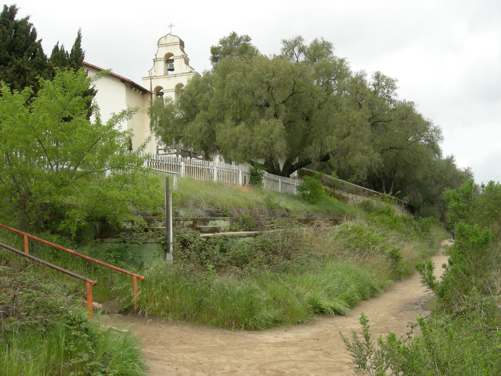 |
| This escarpment is the surface trace of the San Andreas Fault |
 |
| Descendent of original mission pepper trees. |
 |
| No crazed gunmen in this bell tower. |
 |
| Front of the main sanctuary of the mission. |
 |
| Mission-style bell. |
 |
| Plaza Hotel |
 |
| Another descendent of original mission olives trees. |
 |
| Prickly pear in blossom. |
Friday, January 20, 2012
Caliente Ridge Rockhounding Recon
This morning I drove out to the Carrizo Plain with my friend and hiking buddy Mike. En route there I noted more traffic than usual on Highway 58 and once the highway burst out onto the plain I saw all the construction activity relating to the new and controversial Carrizo Energy Solar Farm being constructed there on private land. The location of this facility is actually at the northwest end of the plain in the most populated and man-altered sector of the plain and not near the Carrizo Plain National Monument.
It felt weird seeing all the activity after spending so much quiet time there in the 1990's and 2000's healing my soul and my mind. That period of my life was followed more recently by then not visiting the area hardly at all the past few to several years due to profound changes (albeit mostly positive) in my life. I hope the new activity out there does not spoil the spirit of the place. It certainly was pleasant renewing my acquaintance with my old friend the San Andreas Fault which certainly won't be in any way changed by anything Mankind does out there.
We turned off Highway 58 at Soda Lake Road and passing through California Valley (originally Simmler) and CalFire Station 42 located there we headed into the national monument. We drove up onto Caliente Ridge and parked at the trailhead and then proceeded to head east and up the ridgeline toward Caliente Peak which is actually relatively high for the area at over 5,100 feet in elevation. However, the threat of impending rain turning the road into a quagmire forced us to turn around before reaching the summit and head back and down off the mountain. Along the way I did my usual rockhounding and photography bit and found the following images... and rocks.
All photos by Kim Patrick Noyes (all rights reserved)
It felt weird seeing all the activity after spending so much quiet time there in the 1990's and 2000's healing my soul and my mind. That period of my life was followed more recently by then not visiting the area hardly at all the past few to several years due to profound changes (albeit mostly positive) in my life. I hope the new activity out there does not spoil the spirit of the place. It certainly was pleasant renewing my acquaintance with my old friend the San Andreas Fault which certainly won't be in any way changed by anything Mankind does out there.
We turned off Highway 58 at Soda Lake Road and passing through California Valley (originally Simmler) and CalFire Station 42 located there we headed into the national monument. We drove up onto Caliente Ridge and parked at the trailhead and then proceeded to head east and up the ridgeline toward Caliente Peak which is actually relatively high for the area at over 5,100 feet in elevation. However, the threat of impending rain turning the road into a quagmire forced us to turn around before reaching the summit and head back and down off the mountain. Along the way I did my usual rockhounding and photography bit and found the following images... and rocks.
 |
| Caliente Ridge Road with Soda Lake in the Carrizo Plain in background. |
 |
| Soda Lake with approaching Winter storm. |
 |
| Eastern Soda Lake with dirt road to Selby Campground and Caliente Ridge Road leading up the mountain from the paved Soda Lake Road. |
 |
| Soda Lake in middle background with Caliente Ridge Road visible on spur ridge in middle foreground. |
 |
| Selby Campground as viewed from atop Caliente Ridge. Note the linear rock formations. |
 |
| Soda Lake in the Carrizo Plain and the Temblor Range in the background. |
 |
| View looking west and downhill along Caliente Ridge Trail. Note: no vehicle traffic allowed on this segment. |
 |
| Carrizo Plain in middle foreground with Temblor Range in background. San Andreas Fault surface trace visible at far edge of valley at base of the hills appearing as long, low scarp parallel to the hills running left to right. |
 |
| Southern Sierra Nevada, Tehachapi Mountains, and San Emigdio Mountains in order left to right in background with Temblor Range and Carrizo Plain in middle foreground and Caliente Ridge in near foreground. |
 |
| San Andreas Fault trace runs along the linear low hillock in middle foreground running up the Carrizo Plain. |
 |
| View looking east and uphill along Caliente Ridge Trail. |
 |
| Detail of cluster of interesting rocks exposed by blade of heavy equipment that graded this fire road. |
 |
| More interesting rocks were found in this other cluster of exposed material in the near foreground. |
 |
| View of the Cuyama Valley from Caliente Ridge. |
 |
| Although relatively high up above the surrounding terrain Caliente Ridge is by no means steeps with a few exceptions. |
 |
| My biggest discovery of the day: a platy nodule of quartz and calcite. |
 |
| Detail of my quartz-calcite platy nodule showing quartz at left with calcite at right. |
 |
| Slickenslided sandstone material |
Wednesday, December 14, 2011
A Beautiful Brooding Carrizo Plain
Ten years ago this month I took these images of Winter weather setting onto a brown, dry Carrizo Plain. This was probably the first significant rain of the season out there given how brown the grasses were at the time. This place is very special to me and I have visited it innumerable times throughout the course of two decades and all times of year and in all types of weather. This place is usually rather solitary and disquietingly quiet for the uninitiated. It is also gifted with multiple personality disorder as it has a broad range of many different faces to an extent one would not think possible for such a seemingly plain plain to the untrained eye and mind. Indeed, to the untrained eye the place seems rather barren and lifeless but that is far from true. I can attest to the power of this place as a place of prayer and contemplation and meditation. Much history both human and geologic going back many thousands of years in the former case and many millions of years in the latter case has unfolded here.
For the record, the San Andreas Fault Zone appears in each of these images.
All photos by Kim Patrick Noyes (all rights reserved)
For the record, the San Andreas Fault Zone appears in each of these images.
 |
| A scarp of the San Andreas Fault is highlighted by sunlight. |
 |
| Ominous darkness shrouds the Temblor Range. |
 |
| The Carrizo Plain generates some of the best skyscapes anywhere on the Central Coast. |
 |
| Soda Lake is dry most of the year but when it is not it is an important cog in the Pacific Flyway. |
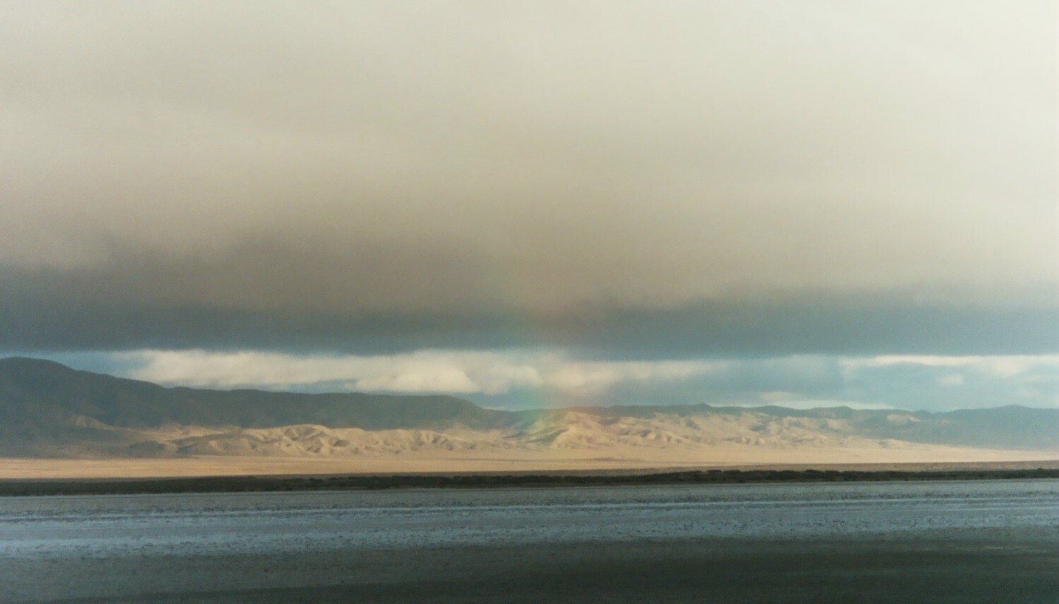 |
| A subtle rainbow seems to paint an illuminated Temblor Range as darkness shrouds Soda Lake. |
All photos by Kim Patrick Noyes (all rights reserved)
Tuesday, November 8, 2011
San Andreas Fault by Natalie Merchant
It might surprise some of you that singer Natalie Merchant wrote and performed a song entitled "San Andreas Fault" that appeared on her 1995 album Tigerlilly. I have included the lyrics to the song below the music video.
Lyrics courtesy of azlyrics.com
Go west
Paradise is there
You'll have all that you can eat
Of milk & honey over there
You'll be the brightest star
The world has ever seen
Sun-baked slender heroine
Of film & magazine
Go west
Paradise is there
You'll have all that you can eat
Of milk & honey over there
You'll be the brightest light
The world has ever seen
The dizzy height of a jet-set life
You could never dream
Your pale blue eyes
Strawberry hair
Lips so sweet
Skin so fair
Your future bright
Beyond compare
It's rags to riches
Over there
San Andreas Fault
Moved its fingers
Through the ground
Earth divided
Plates collided
Such an awful sound
San Andreas Fault
Moved its fingers
Through the ground
Terra cotta shattered
And the walls came
Tumbling down
O, promised land
O, wicked ground
Build a dream
Tear it down
O, promised land
What a wicked ground
Build a dream
Watch it all fall down
Paradise is there
You'll have all that you can eat
Of milk & honey over there
You'll be the brightest star
The world has ever seen
Sun-baked slender heroine
Of film & magazine
Go west
Paradise is there
You'll have all that you can eat
Of milk & honey over there
You'll be the brightest light
The world has ever seen
The dizzy height of a jet-set life
You could never dream
Your pale blue eyes
Strawberry hair
Lips so sweet
Skin so fair
Your future bright
Beyond compare
It's rags to riches
Over there
San Andreas Fault
Moved its fingers
Through the ground
Earth divided
Plates collided
Such an awful sound
San Andreas Fault
Moved its fingers
Through the ground
Terra cotta shattered
And the walls came
Tumbling down
O, promised land
O, wicked ground
Build a dream
Tear it down
O, promised land
What a wicked ground
Build a dream
Watch it all fall down
Lyrics courtesy of azlyrics.com
Saturday, June 25, 2011
An Interesting & Scenic Journey in Photographs
This past Monday I journeyed from Sandy, UT, where I participated in a Gem Faire event, back home to the Central Coast of California. Along the way I captured this series of images minus the ones I took in the Virgin River Gorge which shall be posted here next.


Photos by Kim Patrick Noyes (all rights reserved)

Pine Valley Mountains

Pine Valley Mountains

Pine Valley Mountains

Red rocks north of St. George, Utah.

Pine Valley Mountains

Pine Valley Mountains

Pine Valley Mountains

Interstate-15

Pine Valley Mountains

Interstate-15

Interstate-15 through St. George, UT.

Interstate-15 through St. George, UT.

Interstate-15 in Central St. George, UT.

St. George, UT.

Mojave Desert; Northwest Arizona

Mojave Desert; Northwest Arizona

Interstate-15

Las Vegas, NV, in the distance as viewed from Interstate-15.

Interstate-15 descending into Las Vegas Valley.

Where kitsch is king.

Sand piled by wind upon various hillsides.

Interstate-15 in California's Mojave Desert

Pastel-colored bluffs on the southeast flank of the Calico Mountains.

Famous rockhounding locale Mule Canyon in Calico Mountains.

Calico Mountains; San Bernardino County, CA.

Calico Ghost Town, San Bernardino County, CA

Antelope Fire base camp at the park in Lost Hills, Kern County, CA.

Antelope Fire base camp at the park in Lost Hills, Kern County, CA.

Antelope Fire burn area in the Temblor Range, Kern County, CA.
The fire burned 5,196 acres.

Cholame Valley, San Luis Obispo County, CA

Middle Mountain in middle of photo is underlain by San Andreas Fault Zone.

Cholame Valley is a rift valley of the San Andreas Fault Zone.

Actor James Dean died here September 30, 1955.

CalFire S-2 tanker launching from Paso Robles Air Attack Base.
Photos by Kim Patrick Noyes (all rights reserved)
Subscribe to:
Posts (Atom)