

Showing posts with label wildfires. Show all posts
Showing posts with label wildfires. Show all posts
Saturday, August 22, 2020
Current CA Wildland Fires as of August 22, 2020
Monday, November 11, 2019
Graphic of the Day - Oz Burneth

My friend Dave Touissant grabbed this graphic from MODIS imagery and tweeted it and here it is now on my blog. The extent and magnitude of the fires in Australia just keeps expanding by the day as this is no longer merely limited to New South Wales and Queensland. Imagery courtesy of MODIS.
Tuesday, August 27, 2019
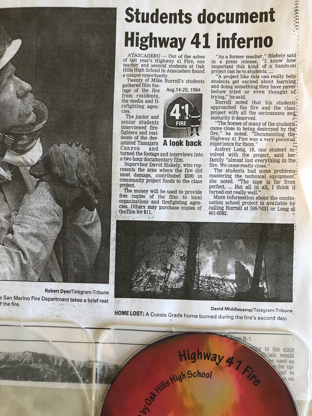
Highway 41 Fire Student Documentary
On August 14, 2019, I had lunch in San Luis Obispo with my 7th grade history teacher Mike Burrell. He was my favorite teacher at Atascadero Junior High School (now Atascadero Middle School) when I was there 1983-1985. En route there from my home in Paso Robles it felt odd to me driving southbound on Highway 101 through the former Highway 41 Fire burn area. It was 25 years to the day after it started and that area would burn the next day. My drive included the area adjacent to Santa Margarita Ranch where the fire jumped the highway as a massive 100 foot wide fire tornado. It also included the entrance to Tassajara Canyon which experienced area ignition conditions when the fire roared through. And lastly, it included Cuesta Grade which was charred entirely, top to bottom, north and south sides of Cuesta Summit.

During lunch I brought this up with Mike and he informed me that in 1995, the year following the Highway 41 Fire, at which point he was then working at Oak Hills High School in Atascadero, he had his students put together a student documentary about the fire. After creating it they burned it on to blank VHS cassettes and sold them for $10 each for a fundraising drive. After lunch I visited his home in SLO for the first time as we were reconnecting after all these years. Heretofore we merely briefly chatted on Facebook from time to time. Mike gave me the grand tour of his library/museum/arboretum/home which was a lot of fun. Before I left he handed me the only extant version of the documentary on disk. I asked him if I could burn some copies and donate them as well as upload the documentary to Youtube to which Mike generously accented.

Back in Paso Robles I took this disk to The Blueprinter and they directed me to Gallagher Video Services in town. I made an appointment and met with Ron Gallagher and told him my expectations. I wanted several copies of this documentary burned and I wanted nice graphic design for them that was apropos in labeling the product and I wanted an mp4 copy of it burned onto a flash drive so I could upload it to Youtube. I did this last week and today it was ready and here you go. At top is the documentary on Youtube. In the middle is the old disk and directly above is a copy of the new disk version produced by Ron Gallagher. Nicely done I think.


Mike also handed me a photocopy of an old SLO Tribune article from 1995 which recounts the story of this documentary. Read it above and if need be zoom in closer so the print is legible.
Thursday, August 15, 2019
Highway 41 Fire Student Video
 |
| Photo by Kim Patrick Noyes (all rights reserved) |
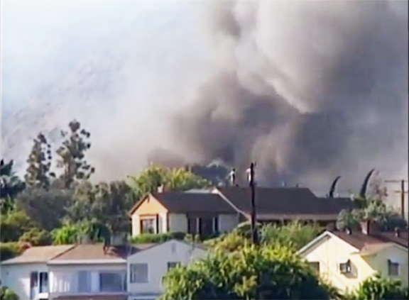
Today I had lunch in San Luis Obispo with my junior high school history mentor Mike Burrell. He was one of those special teachers who left an indelible impression upon me and encouraged my early interest in history. Life took my down a series of unexpected detours so the fruit of his labors with me did not begin blossoming until my 40s when I picked up an AA degree in History at Cuesta College and a BA in History at CAL POLY SLO. Given that today was the 25th anniversary of the Big Blow-Up of the Highway 41 on Day Two of its existence, and I had to drive right through the burn scare of the fire going to San Luis Obispo and back again, it seemed like a perfect coda to this day that Mr. Burrell revealed to me that in 1995 his classes at Oak Hills High School in Atascadero for the first anniversary of the event had created a video documentary about the fire centered around various local video footage taken by local residents and firefighters of the historic conflagration. He also gave me a photocopy of an article in the local SLO Tribune about the video. He has loaned me his copy of the documentary on disc which I am going to copy and upload to Youtube and share on this blog very soon I hope.
Wednesday, August 14, 2019
25th Anniversary of Highway 41 Fire
Twenty-five years ago today the Highway 41 Fire began along the eastbound lane of Highway 41 between Atascadero and Morro Bay near Cerro Alto Campground. The fire, started by an arsonist, exploded across several thousand acres on Day One forcing evacuations, closure of Cerro Alto Campground and closure of Highway 41 between Morro Bay and Atascadero and would remain shut for days to come. The fire barely laid down overnight and reactivated the following morning at dawn making a major run to the west and southwest towards Morro Bay and Highway 1.
At about 6 a.m. on the morning of Day Two (8/15/94) it's early-morning activity caused an automatic power shutdown of the 500kv powerlines running through the area of Cerro Alto Campground taking energy from the Morro Bay Powerplant to points inland.
Day Two saw the fire go nuclear. Well-established in heavy 50 year-old chaparral with up to 40 tons of fuel per acre, most of it desiccated from years of drought (1984-1990) with lots of fallen limbs from two snow storms in 1988 and 1991, an epic freeze in 1990 and then in this year one of the driest winters (Winter of 1993-1994) ever recorded and now on this day triple digit temperatures (hundred-teens inland) with single digit relative humidities. The firestorm that ensued burned up 2 acres per second or over 7,000 acres per hour
The fire savagely tore into the west side of Atascadero, but for the grace of God, causing light damage. It then headed southeast nipping the southwest corner of Atascadero and enveloping the town of Santa Margarita but burning around it, NOT through it.
It jumped Highway 101 and burned both sides of the freeway from just south of Santa Barbara Road in Atascadero all the way down to the bottom of the south side of the Cuesta Grade on the outskirts of San Luis Obispo. The fire burned over Tassajera Ridge and lost steam heading down into Upper Lopez Canyon by which time a day days later a strong marine layer moved inland and dropped coastal drizzle on the fire dousing it.
The fire devastated Tassajara Canyon off of the bottom of the north side of the Cuesta Grade. In all 48,352 acres were charred and 42 homes, 61 other structures and 91 vehicles were destroyed. The arsonist was interviewed but there was never enough evidence to indict.
I have always wondered why a civil case was not pursued against this individual as was successfully done against the arsonist who started the Painted Cave Fire four years earlier.
Monday, August 5, 2019
Monday, July 22, 2019

Picture of the Day - Museum Fire at Dusk

Friday, June 28, 2019
CA Disaster Anniversary Cluster
Today is the middle day in a three-day cluster of notable anniversaries of disasters or significant natural history events in California history. Here are the events in descending order:

1966 M6.0 Parkfield Quake

1990 Painted Cave Fire

1990 College Hills Fire

1991 Sierra Madre Quake

1992 Landers Earthquake

1992 Big Bear Earthquake
June 29th

1925 Santa Barbara Earthquake
JUNE 27th


------------------------------------------------------------------
JUNE 28th


-------------------------------------------------------
Thursday, June 27, 2019
Painted Cave Fire 29th Anniversary
Earlier this evening marked the 29th anniversary of the Painted Cave Fire in Santa Barbara County. Unusually powerful Sundowner winds (hurricane force winds + 109° F by 7 p.m.) combined with the evil in men's hearts to create a firestorm which killed one woman and destroyed 427 buildings and scorched 4,900 acres. Above is a 25th anniversary segment on the local TV news station that aired in 2015.
Wednesday, June 26, 2019
The Dude Fire 29th Anniversary

Monday, June 24, 2019
Graphic of the Day - Arizona MegaFire Comparison
 |
| Image courtesy of NWS Phoenix |
A Bakersfield Kind of Fire
In one of the oddest fires I've seen this year, a small roadside grassfire along Highway 99 in Bakersfield, CA, spread from very meager dry grass into 85 cars on a Carmaxx car sales lot during business hours today. File this under "Only In Bakersfield".
Both videos here courtesy of Power Jamz Productions (all rights reserved).
Both videos here courtesy of Power Jamz Productions (all rights reserved).
Monday, June 17, 2019
Fern Canyon Fuelbreak

Saturday, June 15, 2019
Picture of the Day - McMillan Fire Aerial View

Friday, June 14, 2019
More of My McMillan Fire Footage on Media
Upon awaking this morning and checking online, to my surprise my footage of the 1,764-acre McMillan Fire yesterday had spread across various media sources beyond just AccuWeather last night. This is my first experience with this and I'm getting a small kick out of it. I do not regret giving a few news video gathering organization permission to use my stuff for free. There was nothing special about this fire to be quite honest. If I ever capture something pretty awesome then I will demand money. Below are the versions of my video that appeared today on ABC News, Pattrn, and WeatherNation. Check HERE to see my footage on AccuWeather last night.
Thursday, June 13, 2019
My McMillan Fire Footage On AccuWeather
Tonight I was going to compile my best footage from yesterday's McMillan Fire near Shandon, CA, in eastern San Luis Obispo County. Before I could get a start on doing that I noticed that AccuWeather, which had asked permission to use my videos segments I posted on Twitter during the fire and received said permission, had put together a video montage set to background music on their Twitter channel. Given this is my first time being published like this, I have decided to post the Accuweather video montage instead of less-edited and more raw video. I think you'll enjoy this more polished version best or at least I hope so.
*UPDATE: to see three more versions of my footage as they appear on three other channels/networks HERE.
*UPDATE: to see three more versions of my footage as they appear on three other channels/networks HERE.
Wednesday, June 12, 2019
McMillan Fire Photos
Today while working at my house in Paso Robles, I espied a loom-up of smoke off to the east. I immediately stopped what I was doing and turned on my scanner and checked Twitter and heard and saw references to "McMillan". This told me that the fire was in the area of Hwy 46 and McMillan Canyon Road in the Shandon area. I then without much pre-planning (I neglected to grab water which I later regretted) and headed out the door and out Highway 46 east towards the fire. Below are some of the images I captured shown in order of the incident known as the McMillan Fire. Unfortunately, I didn't realize the camera on my iPhone8 was not set to Auto so some of these images aren't as clear as they should be... sorry! Tomorrow I will see about sharing some of the video shorts I captured. *Update: final acreage was mapped at 1,764 acres.


 <
<


All photos by Kim Patrick Noyes (all rights reserved).


 <
<


Saturday, November 17, 2018

Thursday, June 28, 2018
Moon-rise Over Spring Fire

Subscribe to:
Posts (Atom)