Today while visiting my mother I found that she was already watching this disaster classic and not only that, but the infamous "earthquake scene" was mere minutes away so I waited for it and watched it and then got hooked and finished the movie and in turn neglected to get everything done at mom's place that I had driven nearly 30 miles round trip to do. I still find this more accurate than any other movie interpretation of this city being destroyed by earthquake. Sorry "San Andreas", et al. "Earthquake" IMDB "Earthquake" Wiki

Showing posts with label geology. Show all posts
Showing posts with label geology. Show all posts
Monday, November 11, 2019
Great Los Angeles Earthquake of 1974
Today while visiting my mother I found that she was already watching this disaster classic and not only that, but the infamous "earthquake scene" was mere minutes away so I waited for it and watched it and then got hooked and finished the movie and in turn neglected to get everything done at mom's place that I had driven nearly 30 miles round trip to do. I still find this more accurate than any other movie interpretation of this city being destroyed by earthquake. Sorry "San Andreas", et al. "Earthquake" IMDB "Earthquake" Wiki
Tuesday, July 16, 2019

Monday, May 7, 2018
Nocturnal Kilauea
The ongoing eruption of Kilauea Volcano on the Big Island of Hawaii continues to captivate me. Below is a USGS video published this morning showing events yesterday.
REMINDER: this is really more of a change and escalation of an eruption which actually began in 1983 and has periodically escalated in the past such as in 1990 when a similar change and escalation sent it into Kalapana Gardens which destroyed it. This time, the community of Leilani Estates is being destroyed by an eruptive fissure. This contrasts with the 1990 eruption which destroyed property by way of lavas flows from elsewhere sending lava into the community. This current phase has featured a rather intense earthquake swarm capped by a M6.9 earthquake and a few M5s and many smaller quakes.
REMINDER: this is really more of a change and escalation of an eruption which actually began in 1983 and has periodically escalated in the past such as in 1990 when a similar change and escalation sent it into Kalapana Gardens which destroyed it. This time, the community of Leilani Estates is being destroyed by an eruptive fissure. This contrasts with the 1990 eruption which destroyed property by way of lavas flows from elsewhere sending lava into the community. This current phase has featured a rather intense earthquake swarm capped by a M6.9 earthquake and a few M5s and many smaller quakes.
Monday, March 19, 2018
My First Grey Pines Trail Hike
Today I took another vigorous hike on the west side/main section of Santa Margarita Lake Park with my hiking bros. I'm trying to get into a weekly routine of a 2-3 such hikes as I attempt to get back in physical fitness and lose weight. Below are some of the notable things I observed as I hiked the entirety of the Grey Pines Trail from Grey Pines Flat to Vaca Flat and back.

There are an abundance of interesting sedimentary rock formations.
 This part of the lake is also where the Salinas River Channel used to run before being dam impounded by the Salinas Reservoir Dam.

The main trail skirting the north shore of the lake is visible across the lake from here.

I christened this the Penis Formation for obvious reasons.
 All the rock formations in this area are Miocene sedimentary deposits that have been tectonically lifted at a uniform angle.
 On the way back to the car we encountered these vultures sunning themselves on a tree overlook. They seemed utterly unconcerned with our close proximity. All photos by Kim Patrick Noyes (all rights reserved).


Friday, February 2, 2018
My First 2018 Rinconada Trail Hike
This afternoon I joined my brother by another mother, Mike, and his brother-in-law, for a hike up Rinconada Trail from the trailhead off of Pozo Road to the summit of the Santa Lucia Mountains. in the Santa Lucia District of the Los Padres National Forest. We took the official route up and diverged onto side-routes coming back down. This took us through the upper vestiges of the Rinconada Mine (mercury from cinnabar). Below are images I captured in the order in which I captured them.
 This is a slickenslided chunk of a mineral unknown to me. There is much faulting in this area and evidence of same.


The chaparral in this area has not burned since the Las Pilitas Fire in July, 1985.

This is an unusual example of differentially-aligned slickenslide.

I had never taken today's route down the mountain so this was my first viewing of this surviving adit.

Nature is reclaiming the mining site as evidenced by this nearly-mature digger pine.

Chrysotile asbestos vein in rock boulder in mine tailings.

Pit or partially-collapsed trench?
 Another example of slickenslide to be found in or near the Rinconada Mine revealing the heavily-faulted nature of this cinnabar deposit.
 I wonder what are these odd-looking invasive-looking stalky plants growing in the scar of the EPA remediation of this formerly mercury-contaminated site?
 The retorts used on this site were never removed and can be found in two locations in the lower tiers of this site. All photos by Kim Patrick Noyes (all rights reserved).


Jagged outcropped on north side of the summit.

Another jagged near-summit outcropping: they look igneous to me.


Tuesday, January 30, 2018
Castle Crags Jaunt
Today I joined in on a quick road excursion out into the Machesna Wilderness Area in the La Panza Range on the Santa Lucia District of the Los Padres National Forest in eastern San Luis Obispo County. Most of the way out there I had traversed before but the final part up towards Castle Crags was new to me. We were forced to turn around due to a deep erosion-control drainage swale across the road and the characteristics of the Honda SUV in which we were driving. On the way back we stopped for a short break at the adit for the Queen Bee Mine at and in which I took some photos featured below.

These were the lowest-situated crags we encountered today before turning around. They are clearly old riverine alluvial deposts upthrust by plate tectonics and now being heavily weathered.

The fellas backed back down the road a ways and turned around at the location seen here while I stayed behind to capture images and view the surrounding terrain.

The Queen Bee Mine is a gold-bearing hardrock deposit that was not economically viable and abandoned shortly after being excavated.

The entrance to this adit used to be blocked by a heavy metal grate but that kept getting yanked off by drunken idiots with winches so now it remains open but given the adit ends about 20 feet into the hill there seems to be no need for it.
 I can only imagine why somebody's chonies were left on the floor of the adit. I can certainly think of more romantic places to make "the beast with two backs" but drugs and alcohol can do remarkable things to deprive people of their dignity.
All photos by Kim Patrick Noyes (all rights reserved).

These were the lowest-situated crags we encountered today before turning around. They are clearly old riverine alluvial deposts upthrust by plate tectonics and now being heavily weathered.

The fellas backed back down the road a ways and turned around at the location seen here while I stayed behind to capture images and view the surrounding terrain.

The Queen Bee Mine is a gold-bearing hardrock deposit that was not economically viable and abandoned shortly after being excavated.

The entrance to this adit used to be blocked by a heavy metal grate but that kept getting yanked off by drunken idiots with winches so now it remains open but given the adit ends about 20 feet into the hill there seems to be no need for it.

Friday, May 5, 2017
Picture of the Day - Big Bone Finally Home

Tuesday, April 25, 2017
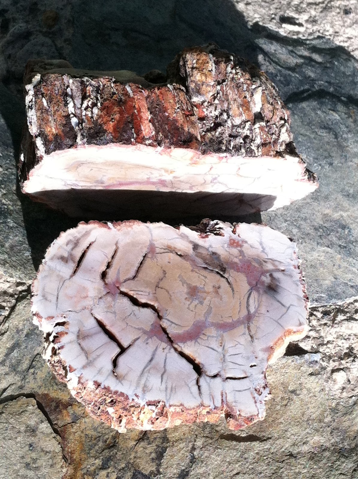
Picture of the Day - Earthquake Pyrite

Tuesday, January 17, 2017
Channel Surfing the Northridge Quake
Twenty-three years ago this morning the M6.7 Northridge Earthquake slammed the Los Angeles Basin killing 57 people. This is a mash-up of recorded live coverage from various television news outlets. This is how I experienced the earthquake that morning, flipping from television station to station and even recording it much as this person did. However, my VHS cassettes are not digitized and saved to Youtube... yet. I watched some of these same live segments replayed here. This is Part One of a series of twenty-four such segments with links to the next-in-sequence appearing on the player on this blog page after the video ends AND being at right of the video player on the corresponding Youtube page for this video if one goes there. Someday in in the not-too-distant future we will be doing this again for another SoCal quake. Be prepared!
Wednesday, December 21, 2016
Graphic of the Day - Tsunami Simplified

Miles Traer strikes again! As with THIS other recent offering by him also produced during his recent visit to the recently-concluded American Geophysical Union Fall Meeting in San Francisco, he explains a potentially complex scientific principle using language and art design capable of benefiting all levels of learners in the spirit of UDL. Image by Miles Traer and courtesy of AGU via Twitter (all rights reserved).
Sunday, December 18, 2016
Graphic of the Day - Food-Lover's Guide To Volcanoes

The American Geophysical Union held its annual autumn conference in San Francisco last week. Since the early 1990s I have enjoyed the earthquake and other type earth science-related disaster presentations and resulting articles in the San Francisco Chronicle as written by legendary science reporter David Perlman. He is now slowing down output given he is 97 but still works for the newspaper. I have not seen any articles by him (or anybody else) about anything presented at this year's conference. Either the corporate nature of modern newspapers has taken the Chron's focus off covering an important science conference in their own City or this year's conference offered fewer things worth placing in the San Francisco Chronicle. However, the most interesting thing coming out of this year's conference I could find was on Twitter which is this graphic by Miles Traer (all rights reserved).
Saturday, November 19, 2016
Cliff's 2016 Annual Tailgater


Thursday, November 3, 2016
Graphic of the Day - Rock Cycle

Wednesday, September 28, 2016
South SAFZ Short-Term Seismic Forecast
This does seem a bit ominous especially when combined with the fact there is hardly any promotion of this earthquake advisory on social media and what exists is presented as innocuously as possible.
Tuesday, August 9, 2016
Of Tsunamis, Whales, Coral, and Sand Dollars
Today the newly-formed, real-life League of Extraordinary Gentlemen conducted a field trip to Santa Barbara County hunting for Miocene Epoch petrified whale bone along the Gaviota Coast as well as anything else of interest that might present itself. After stops at Gaviota and El Capitan State Beaches and a intermediate beach accessed directly from Highway 101 frequented by surfers and nudists, the group headed into Santa Barbara for lunch-dinner at Harry's and a short visit to Chaucer's Bookstore before one more stop at a fossil-bearing site in the San Antonio Valley of northern Santa Barbara County en route home. A wonderful day was had by all. Below are some of the highlights.
 |
| This one-foot-thick iron oxide-stained layer at Gaviota S.B. strikes me as being a prehistoric tsunami deposit (or it could be a turbidite deposit). |
 |
| This verticality of bedding at Gaviota S.B. indicates a fault trace runs through this location. |
 |
| This is a largish boulder of Miocene fossilized coral at El Capitan S.B. I wish I had placed my geologist's hammer on it for scale. |
 |
| Note the presence of calcium carbonate stalactitic formations within the cavity at center of this image of the coral boulder. |
 |
| Large fossilized sand dollar-infused stratified boulder from San Antonio Valley. |
 |
| Fossilized sand dollar in San Antonia Valley excavated and discarded by a gopher. |
 |
| Sand dollar-infused boulder at San Antonio Valley locality we visited today. |
 |
| Close-up of aforementioned sand dollar-infused boulder. |
 |
| Today's fossilized sand dollar finds. |
 |
| My petrified whale bone finds from today. All photos by Kim Patrick Noyes (all rights reserved). |
Friday, May 6, 2016
Picture of the Day - KAP-ing the SAF
 |
| Image of the San Andreas Fault on the Carrizo Plain taken by means of the "Kite Aerial Photography technique." Image courtesy of the USGS (all rights reserved). |
Tuesday, January 26, 2016
Ghosts From Tonight 316 Years Ago
Tonight at about 9:00 p.m. Pacific Standard Time, a M9.0+ earthquake struck the Pacific Northwest, Northern California, and Southwest British Columbia. It was generated by a full rupture of the Cascadia Subduction Zone, a large subduction zone roughly equivalent of the one which caused the Great Tohoku Earthquake in Japan in 2011. This event generated a Pacific-wide tsunami which caused damage in Japan where it was recorded by monks as an "orphan tsunami" as there was no quake in Japan to which it could be attributed. Given Native American oral traditions and tsunami deposits along the coasts of Oregon and Washington, it is clear that there were casualties among local peoples at that time. This earthquake generated lasting topographical changes where parts of the coast were sunk below sea level killing these sitka spruce trees whose roots previously had been in freshwater above the heavier seawater level and in some cases the forests were dropped into the sea as the ocean extended inland. Such a case happened with the Neskowin Ghost Forest along the Oregon Coast in Tillamook County. Before tonight I had not previously seen this haunting relic of not only the 1700 earthquake, but in the case of some trees, other such events over the course of the past two millennium or so. Over that period, successive great quakes have lowered the land in this region. However, the most recent event alone dropped this area by up to 30 feet in elevation.
Monday, January 25, 2016
Graphic of the Day - So Elemental A Table Too
 |
| When looking at/thinking about minerals it is important to think about not only the elements which comprise them (or that they are if they are elemental minerals) but also it is important to think about from whence and when those elements originated. Being the visual creature I am given I am a male of my species, I really like this modality of explaining the origins of various types of known elements. In the Nuclear Science class I am currently taking at Cal Poly we have delved into the origins of the various elemental groupings and I have learned things I never knew before which has been exciting. I enjoy having filled any important gaps in my knowledge of how things work and how they came to be. This is the second time that some formulation of the periodic table has appeared in this Graphic of the Day column on my blog with the previous one being HERE. Chart courtesy of NASA's Cmglee (all rights reserved). |
Sunday, January 10, 2016
Picture of the Day - Transluscent Hallow Pele's Tear
 |
| This is a Pele's Tear, the Hawaiian equivalent of the Apache Tear. This particular one has just been discovered two days ago at Kilauea and is the first of its kind yet discovered. For a better description read the USGS's caption for this image: "This photo shows a one-of-a-kind, completely hollow Pele's tear about 1.5 cm (1/2 inch) long. It was found on the rim of Halemaʻumaʻu and was ejected in association with this morning's explosive event, probably during the aftermath when the lake surface was spattering vigorously." Photo and quoted caption courtesy of USGS's Hawaiian Volcano Observatory (all rights reserved). |
Wednesday, December 2, 2015
Graphic of the Day - So Elemental A Table
 |
| This is my favorite presentation of the periodic table which stands to reason given I am very much a visually-oriented creature. Note: click on the image to zoom in for closer view. |
Subscribe to:
Posts (Atom)