Today while visiting my mother I found that she was already watching this disaster classic and not only that, but the infamous "earthquake scene" was mere minutes away so I waited for it and watched it and then got hooked and finished the movie and in turn neglected to get everything done at mom's place that I had driven nearly 30 miles round trip to do. I still find this more accurate than any other movie interpretation of this city being destroyed by earthquake. Sorry "San Andreas", et al. "Earthquake" IMDB "Earthquake" Wiki

Showing posts with label earthquakes. Show all posts
Showing posts with label earthquakes. Show all posts
Monday, November 11, 2019
Great Los Angeles Earthquake of 1974
Today while visiting my mother I found that she was already watching this disaster classic and not only that, but the infamous "earthquake scene" was mere minutes away so I waited for it and watched it and then got hooked and finished the movie and in turn neglected to get everything done at mom's place that I had driven nearly 30 miles round trip to do. I still find this more accurate than any other movie interpretation of this city being destroyed by earthquake. Sorry "San Andreas", et al. "Earthquake" IMDB "Earthquake" Wiki
Tuesday, July 16, 2019

Friday, July 5, 2019
Graphic of the Day - Just Aftershocks

This is not something you see every day in California.... and these are just aftershocks... this graphic doesn't even show the main shocks. Image courtesy of UC Berkeley Seismo Lab (all rights reserved).
Friday, June 28, 2019
CA Disaster Anniversary Cluster
Today is the middle day in a three-day cluster of notable anniversaries of disasters or significant natural history events in California history. Here are the events in descending order:

1966 M6.0 Parkfield Quake

1990 Painted Cave Fire

1990 College Hills Fire

1991 Sierra Madre Quake

1992 Landers Earthquake

1992 Big Bear Earthquake
June 29th

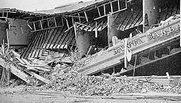
1925 Santa Barbara Earthquake
JUNE 27th


------------------------------------------------------------------
JUNE 28th


-------------------------------------------------------
Saturday, June 22, 2019
Graphic of the Day - Cape Mendo Quake Beach Ball

Tuesday, April 25, 2017
Picture of the Day - Earthquake Pyrite

Thursday, April 13, 2017
Watch An Underwater Earthquake
Tuesday, January 17, 2017
Channel Surfing the Northridge Quake
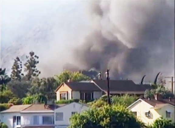
Twenty-three years ago this morning the M6.7 Northridge Earthquake slammed the Los Angeles Basin killing 57 people. This is a mash-up of recorded live coverage from various television news outlets. This is how I experienced the earthquake that morning, flipping from television station to station and even recording it much as this person did. However, my VHS cassettes are not digitized and saved to Youtube... yet. I watched some of these same live segments replayed here. This is Part One of a series of twenty-four such segments with links to the next-in-sequence appearing on the player on this blog page after the video ends AND being at right of the video player on the corresponding Youtube page for this video if one goes there. Someday in in the not-too-distant future we will be doing this again for another SoCal quake. Be prepared!
Wednesday, December 14, 2016
Suddenly Big Blue Boxes

2016 Templeton Earthquake

Thursday, October 20, 2016
Shakeout in the Classroom
Today public and private facilities of various functions conducted the annual Great California Shakeout. It came on a day I was embedded in my classroom at Atascadero High School. I had not heard or read any mention of the annual earthquake preparedness drill being observed at this school and I feared they were not doing it until 10:20 a.m. this date of 10/20/16. Vice Principal Allen broke in over the loudspeaker and narrated an earthquake drill encouraging all students to get under desks and such to protect themselves. I was heartened to see this as I feel this sort of thing is incredibly important and not emphasized enough in society generally. Other sorts of drills at schools are for things like fires and shootings, things which at most schools will never happen. In California there is a 100% probability that a significant earthquake will be experienced at nearly each and every school in the state eventually, something my master teacher/co-teacher pointed out to his drill-disrupted 4th period class this morning. My mom happened to drive by a small Christian pre-school observing the drill at the time appointed so this demonstrates even private education entities participated at least in some cases which I'm heartened to learn. Below is a montage of footage from the Loma Prieta Earthquake (whose 27th anniversary occurred just three days ago) led off by the now-infamous footage of a classroom on the campus of U.C. Santa Cruz getting demolished by the quake. This is followed by a high school gymnasium hosting a girl's volleyball game getting called early. As this footage amply demonstrates, classrooms (and gymnasiums) can be hazardous spaces in a major earthquake. Taking proper precautions such as diving under desks is well-advised. *Note: I forgot to participate in this drill last year so it was nice to get reconnected to it.
Monday, October 17, 2016
Loma Prieta Quake Remembrance In Five Images
I find it nearly unfathomable that it was 27 years ago today that the Loma Prieta Earthquake and the then-concurrent 1989 World Series pitting the San Francisco Giants against their crosstown rivals the Oakland Athletics. Where has the time gone? That was the defining disaster of my coming of age and yet nearly nobody I'm going to school with at Cal Poly and certainly nobody I am teaching at Atascadero High School was even yet born when all that happened. I feel both old and timeless in a contradictory hibridity I cannot adequately put into words.

I still remember CNN Sports Tonight's Fred Hickman referring to the 1989 World Series as "Bays Ball."


I have one or two original copies of this newspaper stored somewhere on the premises.

I have added this location to my bucket list of places in California I wish to visit.
Photo by Fogcat5/Creative Commons.


 |
Photo by Fogcat5/Creative Commons.
Wednesday, September 28, 2016
South SAFZ Short-Term Seismic Forecast
This does seem a bit ominous especially when combined with the fact there is hardly any promotion of this earthquake advisory on social media and what exists is presented as innocuously as possible.
Monday, April 18, 2016
A Fire Began Of The City 110 Years Ago Today
 |
| This is a view of San Francisco 110 years ago today burning as a result of the great earthquake which struck the San Francisco Bay Area at the crack of dawn. The quake and resulting fires destroyed much of the city and killed 3,000-5,000 across the region. The city mostly survived the quake which began under the city and due to directivity, focused much of the quake's energy away from the city north and south down the San Andreas Fault. William Randolph Hearst suggested there wasn't so much a fire in San Francisco than there was a fire of San Francisco and that was accurate. Image in the public domain and photographer is unknown to me. |
Tuesday, January 26, 2016
Ghosts From Tonight 316 Years Ago
Tonight at about 9:00 p.m. Pacific Standard Time, a M9.0+ earthquake struck the Pacific Northwest, Northern California, and Southwest British Columbia. It was generated by a full rupture of the Cascadia Subduction Zone, a large subduction zone roughly equivalent of the one which caused the Great Tohoku Earthquake in Japan in 2011. This event generated a Pacific-wide tsunami which caused damage in Japan where it was recorded by monks as an "orphan tsunami" as there was no quake in Japan to which it could be attributed. Given Native American oral traditions and tsunami deposits along the coasts of Oregon and Washington, it is clear that there were casualties among local peoples at that time. This earthquake generated lasting topographical changes where parts of the coast were sunk below sea level killing these sitka spruce trees whose roots previously had been in freshwater above the heavier seawater level and in some cases the forests were dropped into the sea as the ocean extended inland. Such a case happened with the Neskowin Ghost Forest along the Oregon Coast in Tillamook County. Before tonight I had not previously seen this haunting relic of not only the 1700 earthquake, but in the case of some trees, other such events over the course of the past two millennium or so. Over that period, successive great quakes have lowered the land in this region. However, the most recent event alone dropped this area by up to 30 feet in elevation.
Thursday, December 31, 2015
Top Ten Most Significant Disasters of 2015
Below are what I consider the most significant disasters of 2015 in descending order of relative significance to me. Others undoubtedly and perhaps justifiably would arrange these differently and trade some out for other events not listed. There were other events I was tempted to list but this is my final selection for 2015.
- El Niño 2015-2016 - This event effected the entire world throughout most of the year and whose ancillary events killed thousands of people around the world in droughts, famines, wildfires, floods, storms, landslides, and such.
- Nepal Earthquake - M7.8 event on April 25th in the Himalayan Mountains killed over 9,000 people and injured over 23,000 people.
- Mina Hajj Stampede - The most deadly stampede to date at the hajj in Mecca, Saudi Arabia, killed 2,411 pilgrims on September 24th. Worshippers from all over the world, particularly Persian people, were among the casualties which further soured relations between Saudi Arabia and Iran.
- Russian Metrojet Flight 9268 - This passenger flight was destroyed by an ISIS bomb over the Sinai Desert of Egypt on October 31st killing all 224 people aboard.
- Tianjin Explosions - This spectacular nighttime industrial accident in China on August 12th killed 173 people officially but possibly actually 1,400 people, including 95 of over 1,000 firefighters fighting the fire as well as 11 policemen.
- Illapel Earthquake - M8.3 event on September 16th along the coast of Chile generated a Pacific-wide tsunami with local run-ups to 15 feet and 3 feet in Hawaii. 13 people were killed by the quake and 6 are missing.
- Western North America Drought - The ongoing Western Drought continued this year with California entering its third or fourth year of drought depending upon how one counts it. This drought in the aggregate may become the most costly disaster in United States history. California was the hardest hit by the drought in 2015 which led to water shortages and rationing, massive water pumping and resulting damaging land subsidence in the Central Valley, distressing tree mortality in forests across the state, and unprecedented wildfire behavior.
- Valley Fire - This 76,000 acre fire began on September 12th in Lake County, California. It was pushed by powerful winds in drought-withered fuels quickly over-running a helitack crew burning 4 firefighters on the initial attack and killed four civilians in the following hours. It devastated parts or all of entire communities including Anderson Springs, Cobb, Harbin Hot Springs, Hidden Valley Lake, and Middletown, CA. Destroyed were 1,955 structures including 1,281 homes, 27 multi-family structures, 66 commercial properties and 581 other structures.
- Hurricane Patricia - Strongest cyclone ever recorded in the Western Hemisphere struck Mexico on October 23rd with no casualties (6 were killed earlier in Central America). At its peak it had the most powerful maximum sustained winds ever recorded anywhere on Earth (200 mph) and the lowest barometric pressure ever recorded anywhere on Earth (879 mb).
- Canadian Wildfires - A perfect storm of longer-term climate change, short-term drought, and decades of fire suppression conspired to generate unprecedented wildfire behavior in the boreal forests of Canada this year.
Tuesday, May 5, 2015
Shake of Quake In Katmandu
I first saw the above video a few days ago and still feel it is the most compelling footage yet seen of last week's M7.8 Nepal Quake which so far has killed over 7,500 people. There is one other especially notable video sequence which I have placed below and it features a lot of upset birds as well as people.
Saturday, April 11, 2015
Of Central Coast Volcanoes & Earthquakes
Today I joined my fellow members of the San Luis Obispo Gem & Mineral Club on a most amazing local geology field trip-by-bus. It was headed by geologist Al Stevens and we rented a small shuttle bus so we could all listen to his narration as we drove along. We also made a number of stops to get a closer look at various sites.


 |
| Our rendezvous site at Avila Beach Harbor. |
 |
| Leslie Nelson made the arrangements for this adventure. Here she is handing out the guidebooks to this field trip. |
 |
| Franciscan Formation pillow lava structures at the west end of the Avila Beach Pier parking lot. |
 |
| Another view of the Franciscan Formation pillow lavas which erupted from the ocean floor 180,000,000 years ago when this location was near the equator. |
 |
| Avila Bay with bedrock mortars in the foreground. |
 |
| The Chumash People created this grinding holes over many centuries. |
 |
| Upper Pliocene Squire Sandstone along Avila Beach Drive which is 1.5 million years old and the youngest marine sediment in the San Luis Obispo County. |
 |
| Lower Miocene Obispo Tuff deposited in water about 16 to 20 million years ago during the final phase of the creation of the morros. |
 |
| Miocene Monterey Formation oceanic sediment about 16 to 5 million years ago along San Luis Bay Drive. |
 |
| Upper Pliocene Pismo Sandstone about 3 million years old featuring these expansion features which look like concretions. |
 |
| Edna Valley Fault delineated by line of trees as viewed from US101 south of San Luis Obispo, CA. |
 |
| Lenses of serpentine at Madonna Inn in San Luis Obispo. |
 |
| Dike protruding up through serpentine at same location in San Luis Obispo. |
 |
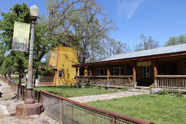
| Madonna Inn |
 |
| Famous/infamous grotto urinal in the Madonna Inn subterranean men's room. |
 |
| Giant clam sinks in the same men's room. |
 |
| This is a view looking east from near the base of the Cuesta Grade. Note the mining excavation on the hill in the foreground. |
 |
| Near the base of the Cuesta Grade looking north towards the grade and the Santa Lucia Range partially created by the Oceanic Fault Zone which appears on the west side of the ridge line. |
 |
| At the intersection of Highways 58 and 229 east of Santa Margarita. |
 |
| Salinian Granite which originated near Palm Springs, CA. |
 |
| Pliocene Paso Robles Formation sediments 1 million to 100,000 years old as found in Pine Mountain Cemetery in Atascadero, CA. |
 |
| The gang in route to the Cholame-Parkfield segment of our adventure. |
 |
| The hill in the foreground is a scarp of the San Andreas Fault at the south end of the Cholame Valley as seen from Davis Road. Note: here where the pipeline crosses the fault it has been run across the surface and expansion joints join the pipe segments so the line won't break even if the fault breaks and there is large offset. |
 |
| Note the fault scarp in the middle foreground trending left to right. |
 |
| This is the San Andreas Fault as seen from near the top of Davis Road. This section broke in the 1857 Fort Tejon Quake. |
 |
| Landslide originating from a spring located along the San Andreas Fault Zone (SAFZ). |
 |
| View northward from the south end of the Cholame Valley as viewed from Davis Road. SAFZ trends from left up the image towards the top which is the north end of the Cholame Valley. |
 |
| David Road headed down into the Cholame Valley and near the intersection of Highways 41 and 46 where actor James Dean died in a collision in 1955. |
 |
| San Andreas Fault as a green grassy swale as viewed from Cholame Valley Road north of Cholame Valley. |
 |
| Westward view of the bridge on the west side of Parkfield, CA. Note: it is bent by the creeping of the SAFZ here. |
 |
| Westward view of bridge railing warped by fault creep. |
 |
| Westward view of west end of bridge. |
 |
| Eastward view of bridge on west side of Parkfield, CA. |
 |
| Eastward view of bridge. |
 |
| Slightly confusing road sign. |
 |
| The San Luis Obispo Gem & Mineral Club gathering for a group portrait. |
 |
| Here we are with a rare image of me (fat guy sitting down). |
 |
| Iconic water tank sign. |
 |
| I love this Franciscan field stone chimney. |
 |
| Words to live by in this place. |
 |
| The gang dining together in celebration of an awesome adventure. |
 |
| Quite a bit of remodeling has occurred at the cafe since last I was here and this is the earthquake-themed northeast corner of the new pool table room . |
 |
| The segment of the cafe visible at left is the add-on to the structure and contains both a pool table room and additional kitchen capacity. |
 |
| This area has also been remodeled a new play structure for the kids and a stage. |

 |
| USGS Earthquake Monitoring Station on the grounds of the CAL FIRE station in Parkfield. |
 |
| Apparently, the Parkfield CAL FIRE station is being relocated. |
 |
| I can confirm this branch was not snapped off in a major earthquake this day. |
 |
| The CAL FIRE station's fire danger sign needs updating: MODERATE. |
 |
| I like a town with a smaller population number than its elevation number. |


 |
| Middle Mountain is at right and sits atop the SAFZ and is often the location for small to moderate earthquakes. SAFOD is located in the distance. All images by Kim Patrick Noyes (all rights reserved). |
Subscribe to:
Posts (Atom)