Showing posts with label local history. Show all posts

Tuesday, August 27, 2019

Highway 41 Fire Student Documentary


On August 14, 2019, I had lunch in San Luis Obispo with my 7th grade history teacher Mike Burrell. He was my favorite teacher at Atascadero Junior High School (now Atascadero Middle School) when I was there 1983-1985. En route there from my home in Paso Robles it felt odd to me driving southbound on Highway 101 through the former Highway 41 Fire burn area. It was 25 years to the day after it started and that area would burn the next day. My drive included the area adjacent to Santa Margarita Ranch where the fire jumped the highway as a massive 100 foot wide fire tornado. It also included the entrance to Tassajara Canyon which experienced area ignition conditions when the fire roared through. And lastly, it included Cuesta Grade which was charred entirely, top to bottom, north and south sides of Cuesta Summit.


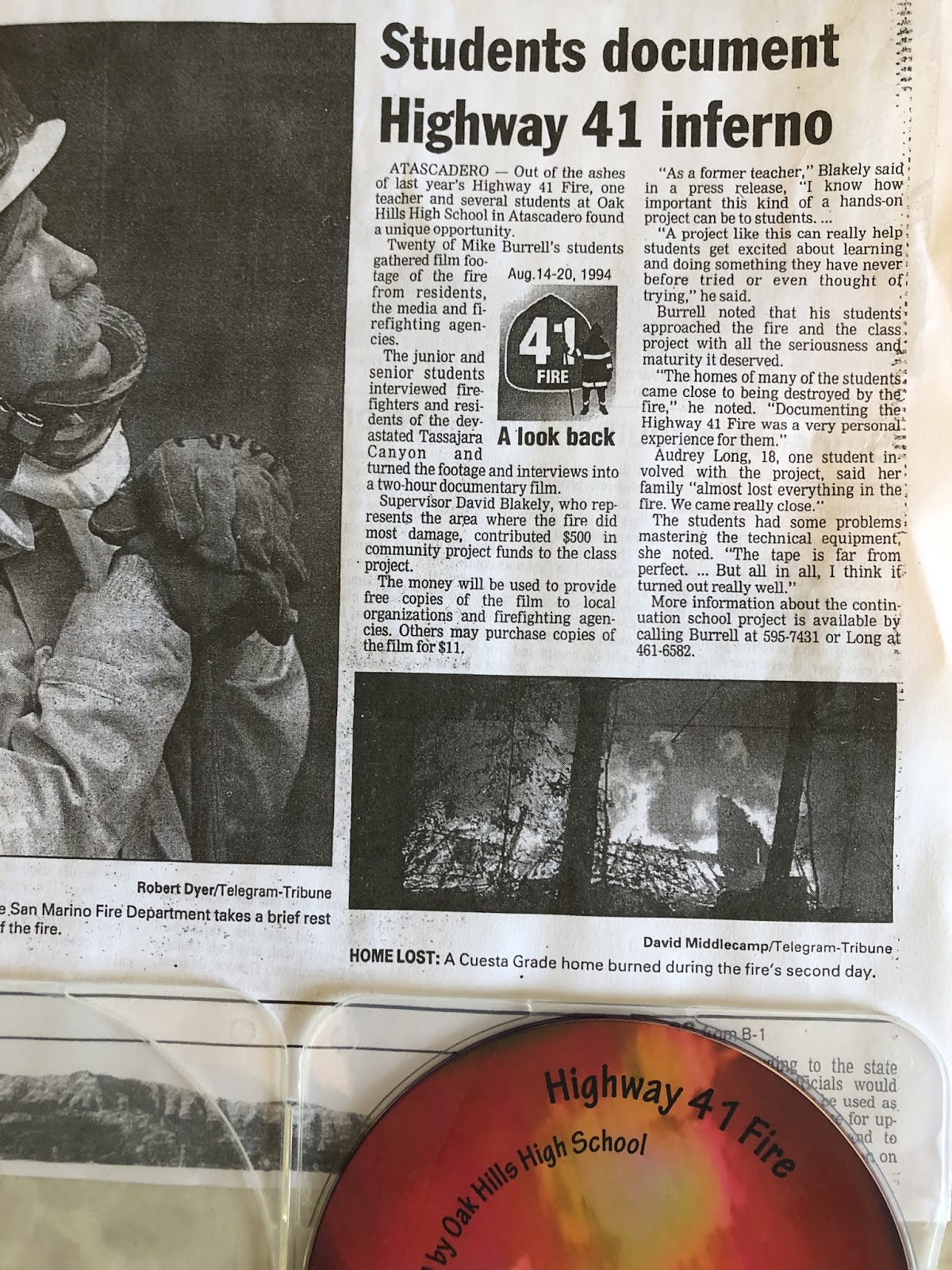
During lunch I brought this up with Mike and he informed me that in 1995, the year following the Highway 41 Fire, at which point he was then working at Oak Hills High School in Atascadero, he had his students put together a student documentary about the fire. After creating it they burned it on to blank VHS cassettes and sold them for $10 each for a fundraising drive.  After lunch I visited his home in SLO for the first time as we were reconnecting after all these years. Heretofore we merely briefly chatted on Facebook from time to time. Mike gave me the grand tour of his library/museum/arboretum/home which was a lot of fun. Before I left he handed me the only extant version of the documentary on disk. I asked him if I could burn some copies and donate them as well as upload the documentary to Youtube to which Mike generously accented.


Back in Paso Robles I took this disk to The Blueprinter and they directed me to Gallagher Video Services in town. I made an appointment and met with Ron Gallagher and told him my expectations. I wanted several copies of this documentary burned and I wanted nice graphic design for them that was apropos in labeling the product and I wanted an mp4 copy of it burned onto a flash drive so I could upload it to Youtube. I did this last week and today it was ready and here you go. At top is the documentary on Youtube. In the middle is the old disk and directly above is a copy of the new disk version produced by Ron Gallagher. Nicely done I think.


Mike also handed me a photocopy of an old SLO Tribune article from 1995 which recounts the story of this documentary. Read it above and if need be zoom in closer so the print is legible.

Thursday, August 15, 2019

Highway 41 Fire Student Video

Photo by Kim Patrick Noyes (all rights reserved)

Today I had lunch in San Luis Obispo with my junior high school history mentor Mike Burrell. He was one of those special teachers who left an indelible impression upon me and encouraged my early interest in history. Life took my down a series of unexpected detours so the fruit of his labors with me did not begin blossoming until my 40s when I picked up an AA degree in History at Cuesta College and a BA in History at CAL POLY SLO. Given that today was the 25th anniversary of the Big Blow-Up of the Highway 41 on Day Two of its existence, and I had to drive right through the burn scare of the fire going to San Luis Obispo and back again, it seemed like a perfect coda to this day that Mr. Burrell revealed to me that in 1995 his classes at Oak Hills High School in Atascadero for the first anniversary of the event had created a video documentary about the fire centered around various local video footage taken by local residents and firefighters of the historic conflagration. He also gave me a photocopy of an article in the local SLO Tribune about the video. He has loaned me his copy of the documentary on disc which I am going to copy and upload to Youtube and share on this blog very soon I hope.

Wednesday, August 14, 2019

25th Anniversary of Highway 41 Fire


Twenty-five years ago today the Highway 41 Fire began along the eastbound lane of Highway 41 between Atascadero and Morro Bay near Cerro Alto Campground. The fire, started by an arsonist, exploded across several thousand acres on Day One forcing evacuations, closure of Cerro Alto Campground and closure of Highway 41 between Morro Bay and Atascadero and would remain shut for days to come. The fire barely laid down overnight and reactivated the following morning at dawn making a major run to the west and southwest towards Morro Bay and Highway 1.

At about 6 a.m. on the morning of Day Two (8/15/94) it's early-morning activity caused an automatic power shutdown of the 500kv powerlines running through the area of Cerro Alto Campground taking energy from the Morro Bay Powerplant to points inland.

Day Two saw the fire go nuclear. Well-established in heavy 50 year-old chaparral with up to 40 tons of fuel per acre, most of it desiccated from years of drought (1984-1990) with lots of fallen limbs from two snow storms in 1988 and 1991, an epic freeze in 1990 and then in this year one of the driest winters (Winter of 1993-1994) ever recorded and now on this day triple digit temperatures (hundred-teens inland) with single digit relative humidities. The firestorm that ensued burned up 2 acres per second or over 7,000 acres per hour

The fire savagely tore into the west side of Atascadero, but for the grace of God, causing light damage. It then headed southeast nipping the southwest corner of Atascadero and enveloping the town of Santa Margarita but burning around it, NOT through it.

It jumped Highway 101 and burned both sides of the freeway from just south of Santa Barbara Road in Atascadero all the way down to the bottom of the south side of the Cuesta Grade on the outskirts of San Luis Obispo. The fire burned over Tassajera Ridge and lost steam heading down into Upper Lopez Canyon by which time a day days later a strong marine layer moved inland and dropped coastal drizzle on the fire dousing it.

The fire devastated Tassajara Canyon off of the bottom of the north side of the Cuesta Grade. In all 48,352 acres were charred and 42 homes, 61 other structures and 91 vehicles were destroyed. The arsonist was interviewed but there was never enough evidence to indict.

I have always wondered why a civil case was not pursued against this individual as was successfully done against the arsonist who started the Painted Cave Fire four years earlier.

.

Friday, February 2, 2018

My First 2018 Rinconada Trail Hike

This afternoon I joined my brother by another mother, Mike, and his brother-in-law, for a hike up Rinconada Trail from the trailhead off of Pozo Road to the summit of the Santa Lucia Mountains. in the Santa Lucia District of the Los Padres National Forest. We took the official route up and diverged onto side-routes coming back down. This took us through the upper vestiges of the Rinconada Mine (mercury from cinnabar). Below are images I captured in the order in which I captured them.

This is a slickenslided chunk of a mineral unknown to me. There is much faulting in this area and evidence of same.

Jagged outcropped on north side of the summit.


Another jagged near-summit outcropping: they look igneous to me.


The chaparral in this area has not burned since the Las Pilitas Fire in July, 1985.

This is an unusual example of differentially-aligned slickenslide.

I had never taken today's route down the mountain so this was my first viewing of this surviving adit.

Nature is reclaiming the mining site as evidenced by this nearly-mature digger pine.

Chrysotile asbestos vein in rock boulder in mine tailings.

Pit or partially-collapsed trench?

Another example of slickenslide to be found in or near the Rinconada Mine revealing the heavily-faulted nature of this cinnabar deposit.

I wonder what are these odd-looking invasive-looking stalky plants growing in the scar of the EPA remediation of this formerly mercury-contaminated site?

The retorts used on this site were never removed and can be found in two locations in the lower tiers of this site. All photos by Kim Patrick Noyes (all rights reserved).

Wednesday, June 28, 2017

Parkhill Fire Country

Last Sunday the latest wildfire began out in the Parkhill Country of San Luis Obispo County. It is the latest in a series of serious and destructive wildfires that narrowly fell short of becoming major historical wildfires. The 2017 installment of this story is the Hill Fire which began along Parkhill Road this past Sunday afternoon and consumed 1,598 acres and 4 homes, including a log cabin and other structures owned by Big Bang Theory actor Johnny Galecki whose 360-acre ranch was destroyed.

A birds-eye view of the early stages of the Hill Fire from the perspective of the air attack orbiting above the fire.
Image courtesy of CAL FIRE (all rights reserved).

The Parkhill Country area due to a convergence of climate and terrain and fuel types and the way people live out there is a firefighting nightmare and has a noteworthy history of wildfires. It is a maze of spur ridges overlain by extensive fuel beds of mature chaparral which region is prone to afternoon northwest winds during the summer fire season. Fires can run uphill almost constantly no matter which way they burn or where in particular they start within this region. This has lent and continues to lend itself to a busy fire history.

The area's biggest largest fire was the Highway 58 Fire which started August 15, 1996, at Black Mountain RV Park on Blue Road. This occurred when a tenant/resident working for reduced rent while clearing out old abandoned vehicles from the property started an old International Harvester parked in tall grass. He was sitting in the driver's seat when he noticed a glow on the grass adjacent to the open driver's side door and realized there was fire underneath the automobile. Things quickly went downhill from there.
The Ackerson Complex was going on in Tulare County and other incidents in the state so aircraft availability was limited during the first hours of the initial attack. In fact, as I recall there were only one or two S-2s dropping on it initially and no air attack so for a time the CHP Air 70 fixed-wing unit did what it could as an aerial observation platform to inform the IC what was happening during the first hour or so of the fire. When the afternoon winds kicked in and combined with where it was headed and the resource availability, the IC fairly early on informed SLO that this was going to be a "major fire incident".... kind of like we have heard on this incident today. It went on to burn 106,668 acres, and about a dozen homes in private inholdings in the LPF and consumed the Machesna Wildnerness Area and threatened condor nesting in the area.

In 2002 there was another Highway 58 Fire started just east of Highway 229/58 intersection which burned east and consumed 1,000 acres and 2 homes.

In 2003 there was a Parkhill Fire which started nearby off Parkhill Rd which burned eastward and consumed 1,200 acres and 3 homes.

In 2012 there was the Calf  Fire which began in private land west of Parkhill Road just west of the community of Parkhill and consumed 640 acres at one point briefly spotting across to the east side of Parkhill Road.

In 2015 there was a Park Hill Fire which started on Las Pilitas Road and burned in the general area of Las Pilitas x Parkhill Road and eastward and consumed 1,791 acres and 6 dwellings of various types.

And now in 2017 there was the Hill Fire which started on Parkhill Road and burned 1,598 acres and 4 dwellings including the aforementioned Galecki ranch. 

Speaking of Las Pilitas, in 1985, a fire began on Las Pilitas Road further west closer to the Salinas River Bridge and burned southward jumping Santa Margarita lake and Pozo Road and ran up into the Santa Lucia Mnts. and the Los Padres NF. A week later a katabatic wind drove it off of Cuesta Ridge down into San Luis Obispo. Aggressive firefighting house to house kept it out and saved SLO. The Las Pilitas Fire scorched 74,6400 acres and 12 homes and closing US101 over the Cuesta Grade for days.

Another Las Pilitas Fire in 1950 killed 4 firefighters (1 CDF & 3 DoD FF's) and charred over 22,000 acres.

Friday, January 13, 2017

Colonial Atascadero Time Capsule Opened

This afternoon at Atascadero High School, a local history encounter broke out at a faculty development meeting. After school as faculty filed into the library for the school-wide meeting, Principal Neely directed staff to behold the just-released contents of the time capsule discovered beneath the cornerstone of the original Margarita Black Union High School building on campus (now called the "B Building"). This structure will soon be torn down to make way for progress and better earthquake safety. The artifacts interred in the time capsule fell into four basic categories: school-related papers, city-related photos, various newspapers, and coins. The time capsule was interred on May 2, 1921. The entire contents of the time capsule have been digitally preserved for posterity per the local historical society. I do not wish to caption each image as I do not know much minutiae about Atascadero history and most people taking the time to read this blog know more about it than me I suspect. In a few instances I will remark for the benefit of those readers knowing even less than I do. Enjoy!

Time capsule cylinder

Some coins of realm were included in the time capsule contents for good measure.

Friday, December 23, 2016

Picture of the Day - A Temple To Temple


Tonight I worked a wedding at the Camp San Luis Obispo Officers Club for the first time (for me). It was rainy and cozy and romantic for the the couple who are both service members, he being a guard at SATCOM up at Camp Roberts and she being in basic training in the US Army as I recall. They were a nice-looking couple and the wedding was charmingly small and casual and in a building with that WWII-era look and feel.

In fact, the place is a veritable museum of photographs of the base in yesterday from exercises to celebrity USO visitors performing. This base is the original home of the California National Guard. The officers club there is a de facto shrine to former California National Guard boss under Governor Reagan and later US Army National Guard boss under President Reagan, Lieutenant General Herbert R. Temple, Jr.

The above primary source document framed and hanging on the wall of a hall across from the restrooms indicates that up through the 1970s the Governor's Office of Emergency Services leader was not an Emergency Manager but rather the head of the California National Guard. We've come a long way!

Monday, December 19, 2016

Picture of the Day - Flamson Gym Floor

For Paso Roblans wondering whatever happened to the Flamson Middle School old basketball gymnasium flooring from prior to the quake retrofit, look no further than here. It is located next door to me, partly being re-purposed on the floor of my neighbor's house. A larger quantity remains for other worthy re-purposing projects of a well-regarded local clan. As an Atascadero Junior High School 8th grade boys basketball Saint, I played basketball against Flamson and later played on this floor against the Bearcats as a junior varsity basketball player my sophomore year of high school at Atascadero High School. Back in the 1980s Paso Robles High School played basketball in the Flamson gymnasium if my memory serves me right. Photo by Kim Patrick Noyes (all rights reserved)

Wednesday, November 23, 2016

Picture of the Day - Reid-Hamilton House at Night

Last night, using my iPhone-4, I shot this image of the historic 1903-built Reid-Hamilton House at 1301 Chestnut Street here in downtown Paso Robles. I walked my dog Tequila past this place both last night and tonight. It was damaged by the 2003 San Simeon Quake and condemned as a consequence and sat abandoned and crumbling for years thereafter. A couple of years ago, money has been poured upon the place expanding it well beyond its original footprint and design turning it into something much more grand than the original. Although this was not a restoration of the old place, per se, I'm pleased to see it stay alive even if in a new and more enhanced incarnation. The construction seems to be complete and landscaping was recently completed as well, using stones from the original building in the landscaping for retainer walls and such. Photo by Kim Patrick Noyes (all rights reserved).

Monday, November 21, 2016

Picture of the Day - Judd's Powerpoint

Tonight I attended the final normal meeting of the Santa Lucia Rockhounds this year. Next month will be a Christmas Dinner and new officer installation meeting at the Culinary Academy here in Paso Robles, CA. I was tasked with providing a speaker for tonight's meeting and I was honored to have my history mentor Dennis Judd give his famous and popular Hearst Castle/San Simeon presentation. He gave this presentation to this club several years ago, but I missed it. Consequently, I was overjoyed to finally see it, although much of this I had seen presented in his History of California class at Cuesta College which class I took in 2011 (and in it earned an A). Tonight I operated Dennis' Powerpoint presentation and during which I snapped this image of his Julia Morgan panel. Afterwards, I indulged in a sanity-saving bread-breaking with Judd and Ron, both friends with whom I have coffee every week. Oh, and yes, Dennis did bring his famous blue-green jade cobble from the Big Sur Coast to show off once again. Photo by Kim Patrick Noyes (all rights reserved).

Sunday, September 25, 2016

Nascent Alta Maria Station

For the second consecutive day I worked most of the day at the old The Station wine bar in Los Alamos soon-to-open-as Alta Maria Station restaurant in the same location. The timing of this intentionally coincided with the town's annual "Old Days" celebration and parade. At the beginning and end of my time there today when things were relatively calm I captured these images of this beautiful and interesting property/venue which first opened as an Old Highway 101 full service station in 1926.

All photos by Kim Patrick Noyes (all rights reserved).